Atlantic Basin Braces for Major Hurricane and Developing Southeast Storm
MIAMI – The Atlantic Ocean is a hotbed of dangerous tropical weather activity as Saturday, September 27, 2025, dawned with Hurricane Humberto reaching a powerful Category 4 status and a separate, rapidly developing system threatening the southeastern United States. The confluence of these weather events has put multiple regions on high alert, prompting emergency declarations and extensive preparations.
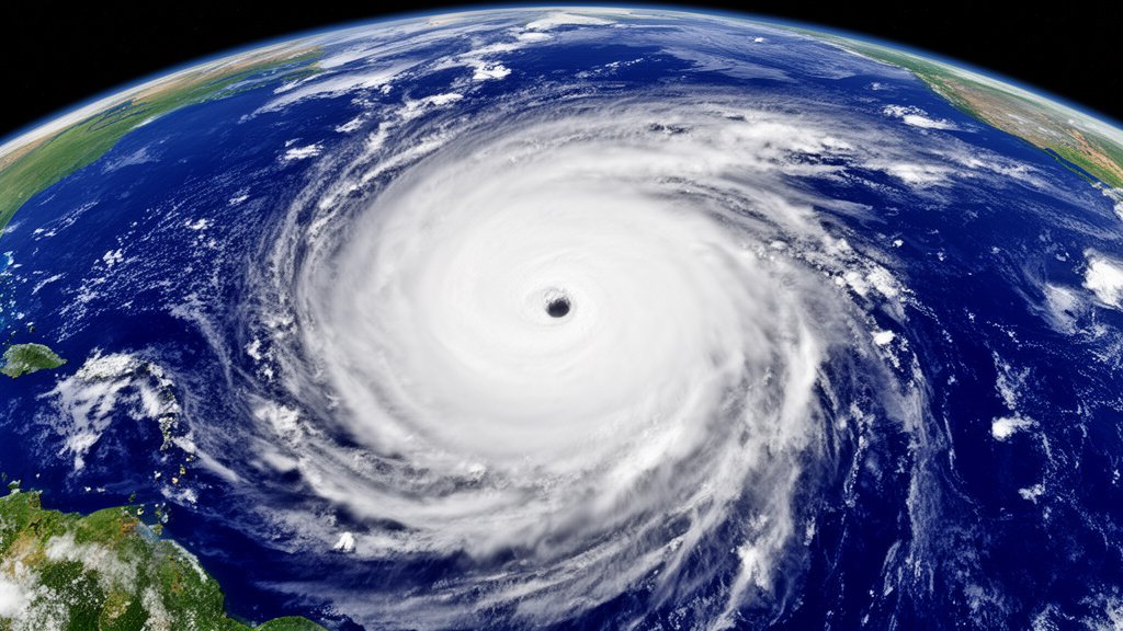
Hurricane Humberto Reaches Major Strength
Hurricane Humberto has intensified significantly, reaching Category 4 status with maximum sustained winds of 145 mph. As of Saturday morning, the storm was located approximately 375 miles northeast of the northern Leeward Islands and was moving westward at 6 mph. The National Hurricane Center (NHC) in Miami forecasts additional strengthening through the weekend, with the potential for Humberto to reach Category 5 intensity, though its intensity may fluctuate due to eyewall replacement cycles. Swells generated by Humberto are already beginning to impact the northern Leeward Islands, the Virgin Islands, Puerto Rico, and Bermuda, bringing with them the threat of life-threatening surf and rip current conditions. Forecasters anticipate Humberto will continue to move around a subtropical ridge before accelerating northeastward later in the week, eventually undergoing extratropical transition. While Humberto itself is not an immediate threat to the U.S. mainland, its powerful circulation could influence the track of other systems.
Southeast U.S. on Alert for New Tropical System
Simultaneously, a distinct weather system, designated Potential Tropical Cyclone Nine and expected to be named Imelda, is developing in the western Atlantic and posing a significant threat to the southeastern United States. This system, described as a disorganized cluster of showers and thunderstorms, has already brought heavy rains to the Dominican Republic, leading to evacuations and a red alert in five provinces. In Azua, a southwestern province, at least 774 people have been displaced. The system is forecast to strengthen into a tropical storm by Sunday and could reach hurricane intensity by late Monday as it approaches the U.S. Southeast coast. While the exact track and intensity remain uncertain, forecasters predict it could bring heavy rainfall, damaging winds, and rough seas to parts of Georgia, the Carolinas, and potentially Virginia by early next week. Some models suggest the storm might stall near the coast, exacerbating rainfall totals.
Preparations Underway Across the Southeast
In anticipation of Potential Tropical Cyclone Nine, several areas have taken precautionary measures. South Carolina Governor Henry McMaster declared a state of emergency for the entire state on Friday, enabling state emergency officials to coordinate resources and personnel. Charleston, South Carolina, Mayor William Cogswell announced a local state of emergency, with crews clearing drains and staging pumps. Other municipalities along the Southeast coast are also implementing preparedness actions. A tropical storm watch has been issued for portions of the Florida coast north of West Palm Beach to north of Daytona Beach. Residents in the Bahamas are also under tropical storm warnings and watches, with heavy rainfall and flooding anticipated.
Broader Atlantic and Pacific Activity
The Atlantic basin’s active weather pattern extends beyond Humberto and Potential Tropical Cyclone Nine. Post-tropical cyclone Gabrielle, formerly a hurricane, is moving away from the Azores, having brought near hurricane-force winds and heavy rain to the archipelago. In the Pacific Ocean, Hurricane Narda, a Category 1 storm, is churning miles west-southwest of Baja California. While not expected to make direct landfall in Southern California, swells generated by Narda are forecast to bring life-threatening surf and rip current conditions to coastal Mexico and Baja California Sur, with potential impacts reaching Southern California over the weekend.
Hurricane Season Context
The 2025 Atlantic hurricane season, initially predicted to be above normal, has seen a surge in activity in its latter half. Hurricane Erin reached Category 5 strength earlier in the season, and Gabrielle and Humberto have both become major hurricanes. This active period underscores the importance of staying informed and prepared, as the season officially continues until November 30. The National Hurricane Center is continuously monitoring these evolving systems, providing crucial updates as they develop. The current complex weather patterns create a dynamic and challenging forecasting situation, highlighting the ongoing need for vigilance across threatened regions. This is a developing headline that continues to capture national attention.
Key Takeaways:
* Hurricane Humberto has intensified into a Category 4 major hurricane.
* A new system, Potential Tropical Cyclone Nine (Imelda), threatens the Southeast U.S. with heavy rain, wind, and possible hurricane conditions.
* States of emergency have been declared in South Carolina and Charleston County.
* Tropical storm watches and warnings are in effect for parts of the Bahamas and Florida.
* Hurricane Narda is generating dangerous surf conditions along the Mexican and Southern California coasts.
As this dangerous tropical weather unfolds, residents in affected areas are urged to monitor official advisories and complete their emergency preparations. The news is trending due to the dual threats and the potential for significant impacts across multiple regions. Stay tuned for further updates on these developing storm systems.