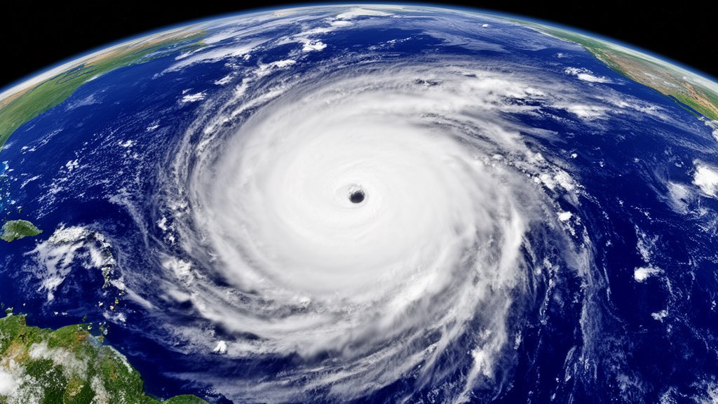
Hurricane Genevieve has officially reached Category 5 status on the Saffir-Simpson Hurricane Wind Scale, packing sustained winds of 160 mph. While the storm represents the pinnacle of atmospheric power in the East Pacific basin, meteorological models from the Miami-based National Hurricane Center (NHC) currently indicate that the hurricane will track parallel to the Mexican coastline rather than making direct landfall. This trajectory offers a critical reprieve for coastal communities, though the sheer scale of the system remains a focal point for regional authorities.
Key Highlights
- Intensity: Hurricane Genevieve has surged to Category 5 strength, characterized by sustained winds of 160 mph.
- Trajectory: The storm is currently tracking parallel to the Mexican coast, with current models showing no expected landfall.
- Monitoring: The National Hurricane Center (NHC) continues to issue constant updates and advisories to track the hurricane’s movement.
The Atmospheric Mechanics of Hurricane Genevieve
Understanding Category 5 Dynamics
The classification of Hurricane Genevieve as a Category 5 hurricane is significant. Under the Saffir-Simpson scale, a Category 5 designation is reserved for storms with sustained wind speeds exceeding 157 mph. At this level, the storm exhibits a well-defined eye, intense spiraling convection, and massive potential for destruction. The rapid intensification seen in Genevieve is often linked to the interaction between the storm’s core and the warm surface temperatures of the East Pacific, which act as a high-octane fuel source for cyclonic systems. The NHC’s ability to track these dynamics with precision relies on a complex web of satellite imagery, hurricane hunter aircraft reconnaissance, and oceanic buoy data, all of which provide the granular statistics necessary to differentiate between a stable, intensifying storm and a weakening one.
Why No Landfall Is Expected
The critical question for coastal residents in Mexico is why, despite the storm’s magnitude, it is not projected to make landfall. The answer lies in the steering currents within the upper atmosphere. High-pressure ridges, typically located to the north or northeast of the storm’s current position, act as a barrier that prevents the cyclone from drifting toward the mainland. In the case of Genevieve, these prevailing wind patterns are effectively acting as a steering mechanism, guiding the storm safely into the open waters of the Pacific. While the storm does not make physical contact with land, its peripheral impact—such as increased swell, elevated rip current risks, and outer rain bands—still requires vigilance.
The Role of the National Hurricane Center (NHC)
The Miami-based NHC serves as the nerve center for tropical cyclone forecasting. In the context of Genevieve, the NHC provides the essential “cones of uncertainty,” which are probabilistic visualizations of where the storm center might travel over the next five days. These models are not static; they are updated every six hours based on the latest data feeds. The accuracy of these models has improved dramatically over the last decade, allowing for more precise warnings and better-informed evacuation decisions. For Genevieve, the NHC’s role is primarily one of constant verification, ensuring that the steering currents do not shift in a way that could bring the storm closer to the coast.
Secondary Angles: Context and Impact
Historical Context of East Pacific Cyclones
The East Pacific basin is often overshadowed by the Atlantic, yet it is one of the most active hurricane regions on the planet. Historically, storms like Genevieve follow specific, climatologically predictable paths. Many East Pacific hurricanes form off the coast of Southern Mexico and track westward, often dissipating in the cooler waters further out to sea. Studying Genevieve through the lens of historical data helps meteorologists understand long-term climate trends. Recent decades have seen a slight shift in the frequency and intensity of storms in this region, often attributed to fluctuating sea-surface temperatures and oceanic heat content.
Regional Economic and Civil Protection Impacts
Even without a direct landfall, a Category 5 storm poses substantial economic challenges. For nations like Mexico, preparedness is a multi-sector operation. Civil protection agencies monitor the storm to determine potential impacts on maritime logistics, tourism-dependent beach economies, and fishing industries. The secondary effects of a “near-miss” storm include the temporary suspension of port operations and potential infrastructure strain on coastal power grids due to high-altitude gusting. The economic cost of preemptive safety measures is often substantial, yet it is widely regarded as a necessary expenditure to mitigate the potential for catastrophic failure should the storm’s path shift unexpectedly.
Future Predictions and Climate Variability
The future behavior of Pacific storms like Genevieve is a subject of intense academic study. Climatologists are looking at the potential for “rapid intensification” events—where a storm jumps several categories in a 24-hour period—to become more frequent. As oceanic temperatures rise, the thermodynamic limit for hurricane strength increases. While Genevieve is currently tracking safely, the meteorological community uses data from this specific event to feed machine learning models that aim to predict future storm behavior with higher fidelity. These insights are vital for long-term disaster risk reduction and infrastructure planning along the Pacific rim.
FAQ: People Also Ask
1. What is the difference between a Category 5 hurricane and a Tropical Storm?
A Tropical Storm has wind speeds between 39 and 73 mph. A Category 5 hurricane is the most severe level on the Saffir-Simpson scale, featuring sustained winds of 157 mph or higher, leading to catastrophic damage.
2. If the storm isn’t making landfall, why is it still dangerous?
Even when a major hurricane remains offshore, it can create life-threatening conditions. These include dangerous rip currents, high surf, and coastal erosion that can impact beaches miles away from the eye of the storm.
3. How does the National Hurricane Center determine the path?
The NHC uses an ensemble of computer models, satellite tracking, and data from hurricane hunter aircraft that fly into the storm to measure pressure, wind speed, and moisture content in real-time.
4. Is Genevieve a unique weather event?
While Category 5 storms are rare, they are a known phenomenon in the East Pacific. Scientists study each event to refine predictive capabilities, but Genevieve fits within the known climatological profile of severe Pacific hurricanes.