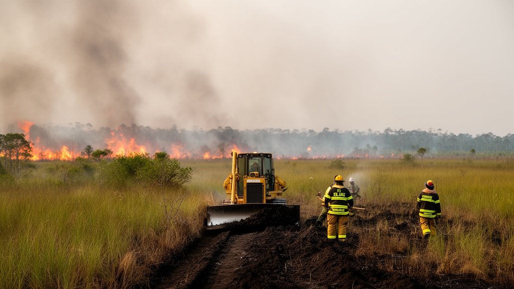
A fast-moving wildfire, officially designated as the Blue Gill Wildfire, has scorched 750 acres of land in west Miami-Dade County, prompting an urgent, multi-agency response as teams fight to establish containment lines. As of the latest update on August 2, the blaze—located near the critical junction of Southwest Eighth Street and Krome Avenue—remains at zero percent containment. Local authorities are managing the situation as conditions remain volatile, with smoke potentially impacting air quality and visibility in the surrounding suburban-wildland interface.
Key Highlights
- Extent of Impact: The Blue Gill Wildfire has burned approximately 750 acres of terrain.
- Containment Status: As of the latest reporting, the blaze is at 0% containment, requiring extensive suppression efforts.
- Strategic Location: The fire is concentrated in the west Miami-Dade region, specifically near the intersection of Southwest Eighth Street and Krome Avenue.
- Emergency Response: Florida Forest Service (FFS) and Miami-Dade Fire Rescue (MDFR) units are actively engaging the fire to protect infrastructure and property.
The Anatomy of the Blue Gill Wildfire
The Blue Gill Wildfire represents a significant tactical challenge for regional emergency responders. The blaze, which ignited in the arid landscape of west Miami-Dade, has rapidly expanded due to the combination of dry ground cover, seasonal heat, and shifting wind patterns. Unlike urban structure fires, wildland fires in the Everglades-interface zone require a specialized approach to suppression that prioritizes the creation of firebreaks and the utilization of controlled burnouts to starve the fire of fuel before it reaches inhabited areas or critical infrastructure along the major thoroughfares of Southwest Eighth Street.
Tactical Challenges in the Everglades Interface
Firefighting in the Bird Drive Basin and the areas flanking Krome Avenue presents unique, often treacherous obstacles. The terrain consists of a complex mosaic of sawgrass, hardwood hammocks, and invasive vegetation, which dries out rapidly during the summer months. When these areas ignite, the fuel load—much of it comprised of dense, volatile brush—allows the fire to spread with alarming speed.
Commanders on the ground from the Florida Forest Service are currently deploying bulldozers to carve out containment lines. These lines are intended to create a buffer zone, stripping the ground to mineral soil to prevent the fire from advancing further. However, the 0% containment status is not necessarily an indication that the fire is out of control in the sense of being an active, unmanaged threat to life, but rather a reflection of the initial phase of operations where the primary goal is to surround the perimeter. Until these lines are fully established and ‘blacked out’—meaning the fire has consumed all available fuel to the perimeter—the containment percentage will remain at zero.
Understanding Fuel Loads and Fire Behavior
In Florida, the management of wildfires is intrinsically linked to the concept of ‘fuel moisture.’ Following several weeks of sporadic rainfall followed by high-heat days, the vegetation in west Miami-Dade has reached a critical dryness level. The Blue Gill Wildfire is feeding on these dry fuels, creating intense heat outputs that can generate its own micro-weather patterns, potentially causing spot fires ahead of the main fire front. This phenomenon, known as ‘spotting,’ makes containment extremely difficult as burning embers can be carried by winds over established fire lines, igniting new pockets of flame.
Furthermore, the presence of invasive species such as the Melaleuca tree, which is highly flammable due to its high oil content, complicates suppression efforts. These trees can burn with extreme intensity, creating flare-ups that force ground crews to retreat and reposition, thereby delaying the progress of containment efforts.
Public Safety and Air Quality Considerations
While the fire is largely situated in less-populated areas, the proximity to the Tamiami Trail (Southwest Eighth Street) and Krome Avenue is a major point of concern for civil authorities. Smoke from the Blue Gill Wildfire has the potential to drift into populated areas of Miami-Dade, creating respiratory hazards for vulnerable populations. Residents in the vicinity, particularly those with asthma or other respiratory conditions, are advised to keep windows closed and limit outdoor exertion.
Additionally, the smoke can severely restrict visibility on roadways. Motorists are urged to exercise extreme caution when driving near the Krome Avenue corridor. Emergency vehicles and heavy equipment are frequently entering and exiting the area, and sudden, dense patches of smoke can turn a high-speed road into a zero-visibility environment in seconds. Florida Highway Patrol (FHP) units are monitoring the situation to assist with potential traffic diversions if smoke levels worsen.
Regional Fire Trends and Future Outlook
The Blue Gill Wildfire serves as a stark reminder of the seasonal risks facing the South Florida ecosystem. The Keetch-Byram Drought Index (KBDI), a common metric used to assess the risk of wildfire in Florida, has been fluctuating, highlighting the volatility of the region’s climate. As the summer continues, the interaction between urban development and the wildlands will continue to pose challenges for fire management agencies.
Looking forward, the success of containment efforts will depend heavily on the ability of the Florida Forest Service and Miami-Dade Fire Rescue to maintain their perimeter lines through the coming days. The coordination between air support—which provides water drops to cool the fire’s edge—and ground crews—who manage the containment lines—will be the deciding factor in bringing the 750-acre blaze to a full standstill.
FAQ: People Also Ask
Q: What does ‘0% containment’ mean for a wildfire?
A: ‘0% containment’ does not mean firefighters are failing. It means that the fire perimeter has not yet been enclosed by containment lines (such as firebreaks or natural barriers). It indicates the fire is in its active suppression phase, and teams are still working to establish a boundary to stop the fire’s spread.
Q: Is the Blue Gill Wildfire threatening homes in Miami-Dade?
A: While the fire is located in an area near Krome Avenue and Southwest Eighth Street, officials are prioritizing the protection of life and property. As of now, the primary concern is the spread of the fire through the dense brush, but authorities are actively monitoring the situation for any threat to nearby infrastructure.
Q: Why is smoke from the fire such a concern for drivers?
A: Smoke can significantly reduce visibility on roadways, creating dangerous driving conditions. Motorists driving near the Tamiami Trail or Krome Avenue should be prepared for sudden changes in visibility and potential traffic disruptions due to emergency vehicle activity.
Q: What role does the Florida Forest Service play in this fire?
A: The Florida Forest Service (FFS) acts as the primary agency for managing wildfires on wildlands in the state. They provide specialized heavy equipment, such as bulldozers to create fire lines, and aerial support to drop water on areas that are difficult for ground crews to reach.